Your Custom Text Here
Featherston is a small town in the Wairarapa, which was once filled with industry and tourism, now is a quick distraction for people driving along state highway 2. Our brief was to create a masterplan which could help revitalise this town.
The masterplan started as a group project, and we thought to bring back what once made featherston great we had to ‘integrate separation’. This meant taking what has divided this town, and turning it into a positive part of the community.
This town has great potential, a lake within cycling distance, walking tracks starting in every direction, a scenic railway and quick link to wellington by rail and car. But these had either not been used to their potential, or had assisted in causing separation. We propose that by using these we could help bring back what made the city great.
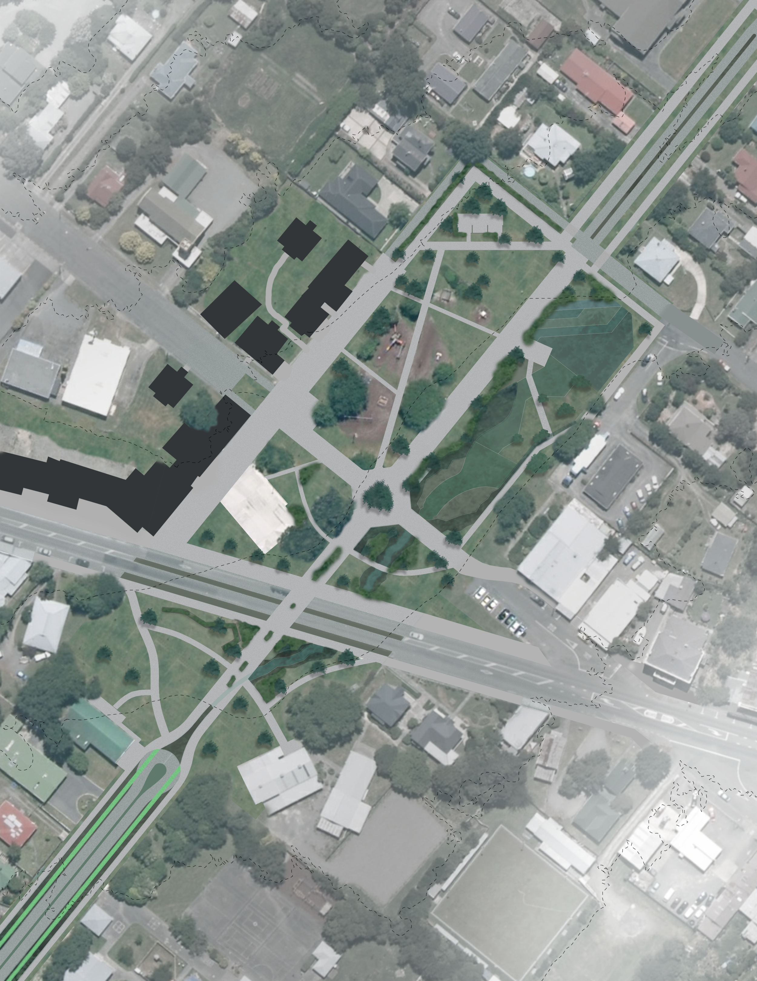
My part of the project focused on a corridor which links the town to the railway station and the lake. It involves redesigning the street scape, a town square and the railway station and parking lot while introducing infrastructure which expresses the towns unique place within the region.
The railway station needed to be redesigned as the current station was constantly exceeding capacity. This meant transferring the station to other side of the tracks and designing a new parking lot to fulfil demand. Because this part of the stream leads to the lake stormwater management has been expressed through the design of each space. In the parking lot, a series of swales, which run through the centre of parking bays, following the original terrain to direct the water to a wider network. This system started to alter how the parking lot was designed.
The town square continued this expression of stormwater infrastructure by utilising retention basins and wetland systems to both clean the water, retain it during common large storm events, and to show how stormwater management is a big part of their region. This space is lined with commercial buildings and facilitates regional activities. Originating from this space are a series of regional cycle ways, and are expressed and enabled through facilities located in this square.
Following on to the lake is a road way designed to promote cycling, and express the collective stormwater management system. It balances safe cycle ways, with parking and exposed stormwater drains. Planting changes towards the lake to become more dependant on water to utilise the rising water table and the excess water which will be running through the system.
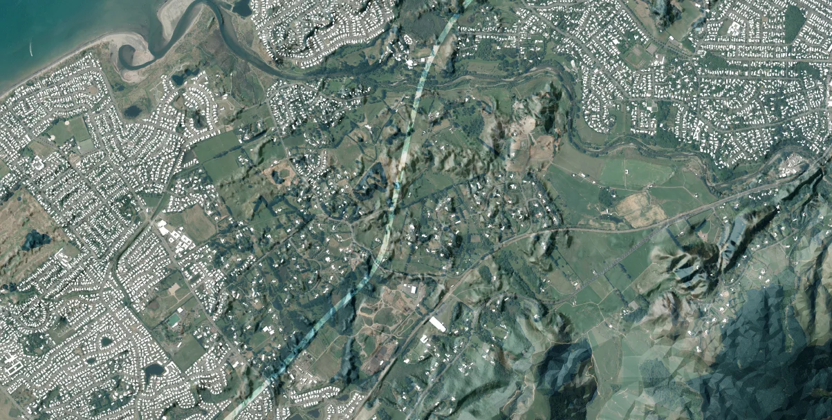
Lake Waiorongomai is a medium sized dune lake found along the kapiti coast. It has spiritual ties to the local iwi, so I began this project talking with them and discussing their hopes for the future of the land, along with their history and traditions. There were many stories about this land, so in a group of a few people we decided to write them down and translate them onto a map of the site. This gave us a great ability to be able to view the land like a landscape architect, but also see the stories and customs that the people of the land know of.
The people of the iwi have a great interest in education and guardianship of the land, this lead me to the idea of creating a horticultural school on the site. Through a phase of analysis I found that the land would be suitable for a horticultural school, but more importantly I found multiple places where a school could be located on this site based on a map of the oral narratives. This gave the indication that the school could be spread out over the land, rather than in just one spot. There was a history of a transferal of knowledge on this site, basing parts of the school in these locations seemed right.
The main school was designed to have a series of welcoming spaces, like a traditional marae would have. Alongside the entrance spaces are plants which are traditionally used for food, medical supplies, or which denote education. Directly in front of the school is recreational areas, surrounded by planting beds used to grow vegetation close to the school. The building would be tucked at the foot of a hill, and would be lost in the vegetation surrounding it.
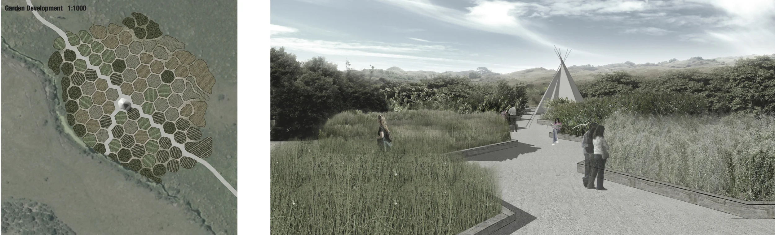
Horticultural schools need space to plant and grow various species in various different soils while having facilities to maintain them and study their growth. This land offered a variety of different conditions to grow in, but visually and ecologically it had been made barren while being farmed. I was looking for a way to be able to utilise the landfor education, but after a plot has been utilised what has grown isn’t removed, but allowed to continue growing to repopulate the land.
To allow this to happen small structures would be erected on the land which help facilitate education and maintenance while students are studying the plants, and provide for a public educational space after the land has been used. A structure would sit within a field of modular planting beds which could be left to grow outside of their boundaries after the class has stopped using them. This structure could be removed and moved to another site, or left to provide shelter for visitors. The idea behind the modular planting beds is over time plants will grow in areas where they are best suited for, with soil types changing quickly in a dune lake like this it is uncertain exactly what might be best for where. With a modular exploration like this, classes could plant, maintain and study plants, while making educated decisions on what to plant where, leaving the plants with the ability to supersede the class itself.
This project on Miramar started with a landscape amenity assessment, an d then developed into a design and construction project.
In this project I learnt how to assess the characteristics of a landscape and assign value into how these areas should be managed or utilised.
From this the project developed into a quick exploration of how to fit in a residential development into an area of high landscape character, without negatively affecting that character. Building off of this conceptual design was a phase of design construction details.
This project had a design construction focus, and looked into how a pedestrian bridge might be designed which stretches over the Hutt river. It was an exploration of how to draw and convey construction details, as well as how to design elements for human interaction. This was a formal drawing exploration, and was the first project that exposed me to formal design drawings and construction details.