


Your Custom Text Here
Featherston is a small town in the Wairarapa, which was once filled with industry and tourism, now is a quick distraction for people driving along state highway 2. Our brief was to create a masterplan which could help revitalise this town.
The masterplan started as a group project, and we thought to bring back what once made featherston great we had to ‘integrate separation’. This meant taking what has divided this town, and turning it into a positive part of the community.
This town has great potential, a lake within cycling distance, walking tracks starting in every direction, a scenic railway and quick link to wellington by rail and car. But these had either not been used to their potential, or had assisted in causing separation. We propose that by using these we could help bring back what made the city great.
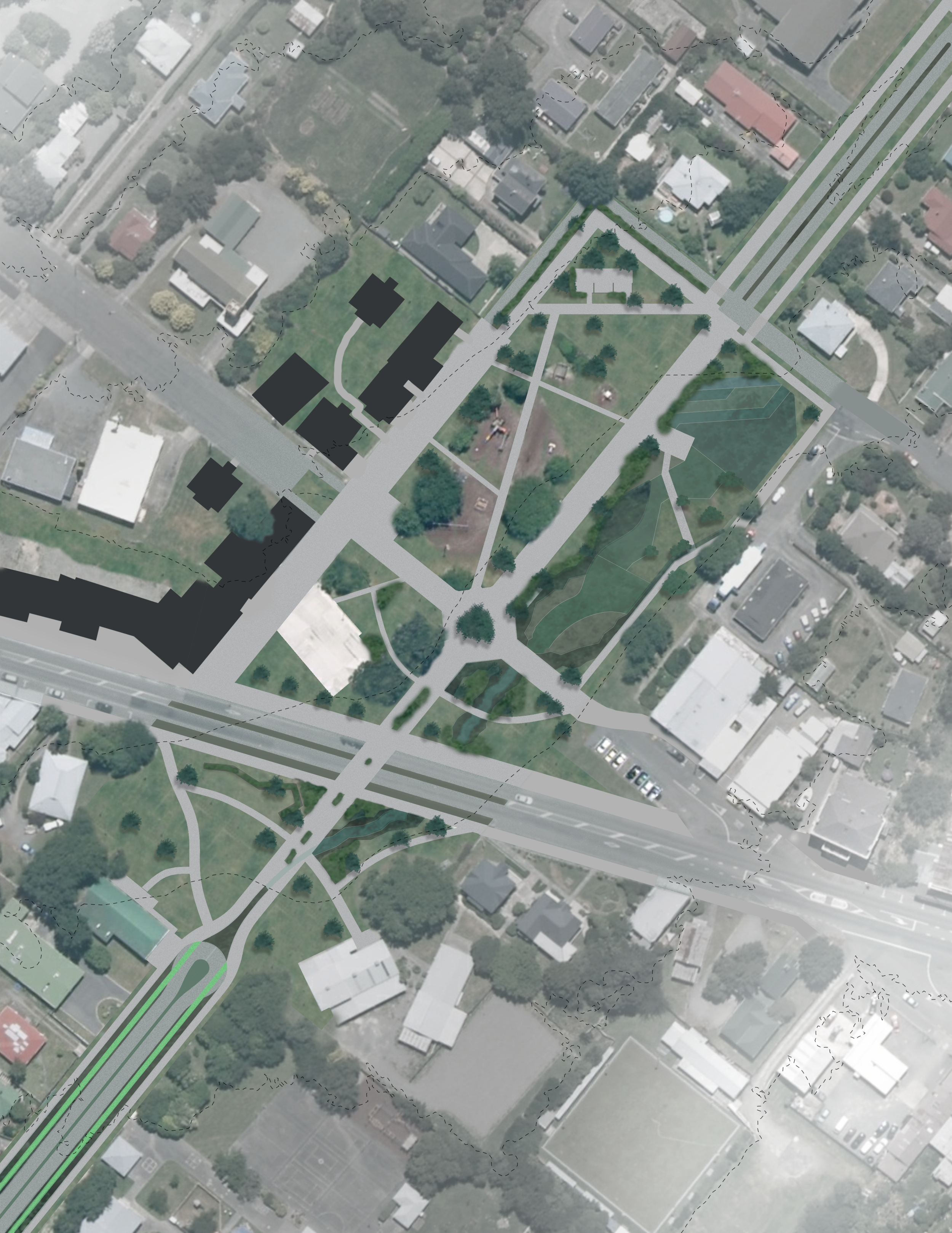
My part of the project focused on a corridor which links the town to the railway station and the lake. It involves redesigning the street scape, a town square and the railway station and parking lot while introducing infrastructure which expresses the towns unique place within the region.
The railway station needed to be redesigned as the current station was constantly exceeding capacity. This meant transferring the station to other side of the tracks and designing a new parking lot to fulfil demand. Because this part of the stream leads to the lake stormwater management has been expressed through the design of each space. In the parking lot, a series of swales, which run through the centre of parking bays, following the original terrain to direct the water to a wider network. This system started to alter how the parking lot was designed.
The town square continued this expression of stormwater infrastructure by utilising retention basins and wetland systems to both clean the water, retain it during common large storm events, and to show how stormwater management is a big part of their region. This space is lined with commercial buildings and facilitates regional activities. Originating from this space are a series of regional cycle ways, and are expressed and enabled through facilities located in this square.
Following on to the lake is a road way designed to promote cycling, and express the collective stormwater management system. It balances safe cycle ways, with parking and exposed stormwater drains. Planting changes towards the lake to become more dependant on water to utilise the rising water table and the excess water which will be running through the system.
Featherston is a small town in the Wairarapa, which was once filled with industry and tourism, now is a quick distraction for people driving along state highway 2. Our brief was to create a masterplan which could help revitalise this town.
The masterplan started as a group project, and we thought to bring back what once made featherston great we had to ‘integrate separation’. This meant taking what has divided this town, and turning it into a positive part of the community.
This town has great potential, a lake within cycling distance, walking tracks starting in every direction, a scenic railway and quick link to wellington by rail and car. But these had either not been used to their potential, or had assisted in causing separation. We propose that by using these we could help bring back what made the city great.
My part of the project focused on a corridor which links the town to the railway station and the lake. It involves redesigning the street scape, a town square and the railway station and parking lot while introducing infrastructure which expresses the towns unique place within the region.
The railway station needed to be redesigned as the current station was constantly exceeding capacity. This meant transferring the station to other side of the tracks and designing a new parking lot to fulfil demand. Because this part of the stream leads to the lake stormwater management has been expressed through the design of each space. In the parking lot, a series of swales, which run through the centre of parking bays, following the original terrain to direct the water to a wider network. This system started to alter how the parking lot was designed.
The town square continued this expression of stormwater infrastructure by utilising retention basins and wetland systems to both clean the water, retain it during common large storm events, and to show how stormwater management is a big part of their region. This space is lined with commercial buildings and facilitates regional activities. Originating from this space are a series of regional cycle ways, and are expressed and enabled through facilities located in this square.
Following on to the lake is a road way designed to promote cycling, and express the collective stormwater management system. It balances safe cycle ways, with parking and exposed stormwater drains. Planting changes towards the lake to become more dependant on water to utilise the rising water table and the excess water which will be running through the system.